Roeulx night lights from space
Night Light of Roeulx (Wallonia) from space (Belgium) Src. Average luminocity for 10x10km area is 44.2703% and for 50x50km: 33.6833%.
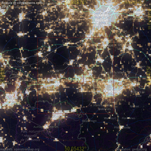
Analysis of Roeulx night lights 2016
Square area 10x10 km:
 4.9%
4.9%90-99
9.38%80-89
5.18%70-79
7.7%60-69
4.34%50-59
6.58%40-49
5.6%30-39
9.8%20-29
14.99%10-19
29.69%0-9
1.82%Square area 50x50 km:
4.28%90-99
5.27%80-89
3.35%70-79
4.57%60-69
5.15%50-59
5.79%40-49
5.64%30-39
6.41%20-29
11.2%10-19
22.23%0-9
26.11%Clear (daylight) street map image can be seen on geolist.org.
Map coordinates:
50° 56' 55.5" North, 3° 24' 30.6" East
50° 30' 13.1" North, 4° 6' 41.9" East
50° 3' 15.6" North, 4° 48' 53.1" East
Some cities around Roeulx sort by population:
• La Louvière
5.7 km =3.5 mi,  109°
109°
• Binche
10.9 km =6.8 mi,  159°
159°
• Soignies
8.9 km =5.5 mi,  341°
341°
• Manage
8.8 km =5.5 mi,  90°
90°
• Morlanwelz-Mariemont
10.9 km =6.8 mi,  119°
119°
• Seneffe
11.1 km =6.9 mi,  73°
73°
• Écaussinnes-d’Enghien
8.1 km =5 mi,  28°
28°
• Estinnes-au-Val
10.4 km =6.5 mi,  182°
182°
2787878 (p: 7,968)
Sources (retrieved 2019-11-25):
» Earth at Night: Flat Maps 2012, 2016