Estinnes-au-Val night lights from space
Night Light of Estinnes-au-Val (Wallonia) from space (Belgium) Src. Average luminocity for 10x10km area is 17.8319% and for 50x50km: 29.619%.
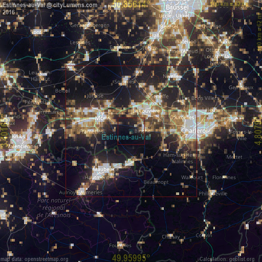
Analysis of Estinnes-au-Val night lights 2016
Square area 10x10 km:
 0.84%
0.84%90-99
2.1%80-89
0.98%70-79
0.84%60-69
2.94%50-59
3.5%40-49
3.5%30-39
2.24%20-29
8.26%10-19
25.21%0-9
49.58%Square area 50x50 km:
4.04%90-99
4.93%80-89
3.03%70-79
3.67%60-69
4.4%50-59
4.83%40-49
4.78%30-39
4.92%20-29
9.62%10-19
20.03%0-9
35.77%Clear (daylight) street map image can be seen on geolist.org.
Map coordinates:
50° 51' 22.1" North, 3° 24' 5.9" East
50° 24' 36.6" North, 4° 6' 17.2" East
49° 57' 35.8" North, 4° 48' 28.4" East
Some cities around Estinnes-au-Val sort by population:
• Mons
11.9 km =7.4 mi,  294°
294°
• La Louvière
10.3 km =6.4 mi,  34°
34°
• Binche
4.2 km =2.6 mi,  87°
87°
• Morlanwelz-Mariemont
11.1 km =6.9 mi,  63°
63°
• Anderlues
11.8 km =7.3 mi, 91°
• Erquelinnes
11.5 km =7.1 mi,  177°
177°
• Roeulx
10.4 km =6.5 mi,  2°
2°
• Chasse Royale
11.2 km =7 mi,  280°
280°
2798597 (p: 7,573)
Sources (retrieved 2019-11-25):
» Earth at Night: Flat Maps 2012, 2016