Quaregnon night lights from space
Night Light of Quaregnon (Wallonia) from space (Belgium) Src. Average luminocity for 10x10km area is 74.437% and for 50x50km: 26.6501%.
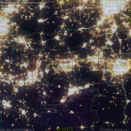
Analysis of Quaregnon night lights 2016
Square area 10x10 km:
 13.03%
90-99
17.09%80-89
15.41%70-79
13.45%60-69
10.92%50-59
18.21%40-49
8.82%30-39
0.98%20-29
2.1%10-19
0%0-9
0%Square area 50x50 km:
3.38%90-99
4.24%80-89
2.47%70-79
2.88%60-69
3.56%50-59
4.18%40-49
4.43%30-39
4.71%20-29
8.99%10-19
22.04%0-9
39.13%Clear (daylight) street map image can be seen on geolist.org.
Map coordinates:
50° 53' 10.9" North, 3° 9' 43.8" East
50° 26' 26.4" North, 3° 51' 55.1" East
49° 59' 26.7" North, 4° 34' 6.3" East
Some cities around Quaregnon sort by population:
• Mons
6.3 km =3.9 mi,  76°
76°
• Saint-Ghislain
3.4 km =2.1 mi,  284°
284°
• Frameries
4.4 km =2.7 mi,  150°
150°
• Boussu
5.1 km =3.2 mi,  261°
261°
• Colfontaine
3 km =1.9 mi,  192°
192°
• Dour
7.9 km =4.9 mi,  231°
231°
• Quévy-le-Petit
9.4 km =5.8 mi, 147°
• Chasse Royale
6.2 km =3.9 mi,  102°
102°
2788499 (p: 18,491)
Sources (retrieved 2019-11-25):
» Earth at Night: Flat Maps 2012, 2016