Basse Lasne night lights from space
Night Light of Basse Lasne (Wallonia) from space (Belgium) Src. Average luminocity for 10x10km area is 40.0321% and for 50x50km: 42.4204%.
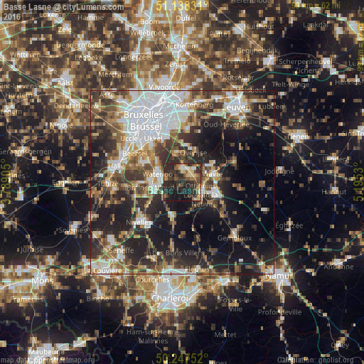
Analysis of Basse Lasne night lights 2016
Square area 10x10 km:
 2.14%
2.14%90-99
2.81%80-89
8.02%70-79
4.55%60-69
6.68%50-59
5.35%40-49
8.29%30-39
11.5%20-29
31.02%10-19
19.52%0-9
0.13%Square area 50x50 km:
9.91%90-99
7.42%80-89
3.55%70-79
4.38%60-69
5.59%50-59
6.15%40-49
6.61%30-39
8.32%20-29
12.45%10-19
18.07%0-9
17.55%Clear (daylight) street map image can be seen on geolist.org.
Map coordinates:
51° 8' 17.9" North, 3° 47' 20.6" East
50° 41' 42.1" North, 4° 29' 31.8" East
50° 14' 51.1" North, 5° 11' 43.1" East
Some cities around Basse Lasne sort by population:
• Braine-l'Alleud
8.8 km =5.5 mi,  261°
261°
• Wavre
8.1 km =5 mi,  72°
72°
• Waterloo
6.9 km =4.3 mi,  288°
288°
• Rixensart
3 km =1.9 mi,  50°
50°
• Hoeilaart
8.2 km =5.1 mi,  348°
348°
• Ottignies
6.2 km =3.9 mi,  122°
122°
• Court-Saint-Étienne
8.7 km =5.4 mi,  141°
141°
• La Hulpe
4 km =2.5 mi, 353°
2802610 (p: 13,861)
Sources (retrieved 2019-11-25):
» Earth at Night: Flat Maps 2012, 2016