Estaimpuis night lights from space
Night Light of Estaimpuis (Wallonia) from space (Belgium) Src. Average luminocity for 10x10km area is 65.2955% and for 50x50km: 44.1764%.
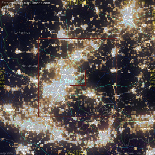
Analysis of Estaimpuis night lights 2016
Square area 10x10 km:
 22.99%
90-99
14.71%80-89
4.28%70-79
4.41%60-69
6.28%50-59
9.22%40-49
9.36%30-39
10.7%20-29
15.24%10-19
2.81%0-9
0%Square area 50x50 km:
10.41%90-99
8.14%80-89
3.82%70-79
4.97%60-69
6.03%50-59
6.76%40-49
6.69%30-39
7.34%20-29
11.32%10-19
16.56%0-9
17.95%Clear (daylight) street map image can be seen on geolist.org.
Map coordinates:
51° 8' 52.9" North, 2° 33' 53" East
50° 42' 17.5" North, 3° 16' 4.3" East
50° 15' 26.7" North, 3° 58' 15.5" East
Some cities around Estaimpuis sort by population:
• Roubaix, FR
6.7 km =4.2 mi,  259°
259°
• Tourcoing, FR
7.8 km =4.8 mi,  285°
285°
• Mouscron
6.2 km =3.9 mi,  315°
315°
• Wattrelos, FR
3.5 km =2.2 mi, 263°
• Hem, FR
8.1 km =5 mi,  224°
224°
• Lys-lez-Lannoy, FR
5.6 km =3.5 mi, 220°
• Leers, FR
3 km =1.9 mi,  213°
213°
• Pecq
5.4 km =3.4 mi,  112°
112°
2798604 (p: 9,340)
Sources (retrieved 2019-11-25):
» Earth at Night: Flat Maps 2012, 2016