Éghezée night lights from space
Night Light of Éghezée (Wallonia) from space (Belgium) Src. Average luminocity for 10x10km area is 6.5749% and for 50x50km: 18.9324%.
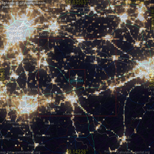
Analysis of Éghezée night lights 2016
Square area 10x10 km:
 0.4%
0.4%90-99
1.2%80-89
0%70-79
0.67%60-69
1.07%50-59
0.4%40-49
1.34%30-39
0.8%20-29
0%10-19
2.94%0-9
91.18%Square area 50x50 km:
1.52%90-99
2.28%80-89
1.53%70-79
2.2%60-69
2.52%50-59
2.89%40-49
4.23%30-39
3.53%20-29
5.95%10-19
19.51%0-9
53.84%Clear (daylight) street map image can be seen on geolist.org.
Map coordinates:
51° 2' 6.1" North, 4° 12' 31.1" East
50° 35' 26.7" North, 4° 54' 42.3" East
50° 8' 32.1" North, 5° 36' 53.6" East
Some cities around Éghezée sort by population:
• Namur
14.1 km =8.8 mi,  192°
192°
• Gembloux
15.4 km =9.6 mi,  257°
257°
• Hannut
14.8 km =9.2 mi,  52°
52°
• Jodoigne
15.1 km =9.4 mi,  348°
348°
• Perwez
7.9 km =4.9 mi,  298°
298°
• Walhain-Saint-Paul
15.6 km =9.7 mi,  284°
284°
• Ramillies
4.9 km =3 mi, 351°
• Braives
15.9 km =9.9 mi,  79°
79°
2798949 (p: 14,352)
Sources (retrieved 2019-11-25):
» Earth at Night: Flat Maps 2012, 2016