Jodoigne night lights from space
Night Light of Jodoigne (Wallonia) from space (Belgium) Src. Average luminocity for 10x10km area is 9.0668% and for 50x50km: 21.6517%.
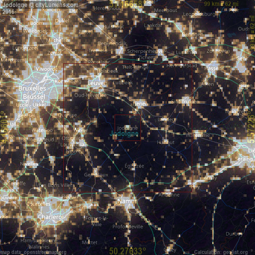
Analysis of Jodoigne night lights 2016
Square area 10x10 km:
 0.53%
0.53%90-99
0.53%80-89
0.13%70-79
0.13%60-69
1.07%50-59
1.87%40-49
2.94%30-39
0.8%20-29
3.07%10-19
9.76%0-9
79.14%Square area 50x50 km:
1.96%90-99
2.64%80-89
1.62%70-79
2.05%60-69
3.01%50-59
3.39%40-49
5.36%30-39
4.92%20-29
6.75%10-19
20.64%0-9
47.66%Clear (daylight) street map image can be seen on geolist.org.
Map coordinates:
51° 9' 59.7" North, 4° 9' 57.6" East
50° 43' 24.9" North, 4° 52' 8.9" East
50° 16' 34.8" North, 5° 34' 20.1" East
Some cities around Jodoigne sort by population:
• Tienen
10.5 km =6.5 mi,  27°
27°
• Grez-Doiceau
12.1 km =7.5 mi,  278°
278°
• Chaumont-Gistoux
11.6 km =7.2 mi,  243°
243°
• Boutersem
12.6 km =7.8 mi,  348°
348°
• Perwez
11.7 km =7.3 mi,  199°
199°
• Beauvechain
9.4 km =5.8 mi,  313°
313°
• Hoegaarden
6 km =3.7 mi,  13°
13°
• Ramillies
10.2 km =6.3 mi,  167°
167°
2794895 (p: 11,930)
Sources (retrieved 2019-11-25):
» Earth at Night: Flat Maps 2012, 2016