Braives night lights from space
Night Light of Braives (Wallonia) from space (Belgium) Src. Average luminocity for 10x10km area is 6.7821% and for 50x50km: 19.3558%.
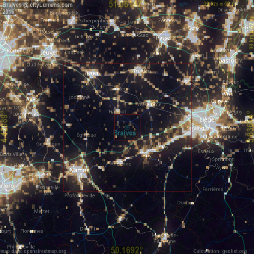
Analysis of Braives night lights 2016
Square area 10x10 km:
100  0%
0%
90-99 0%
80-89 0%
70-79 0.53%
60-69 0%
50-59 0%
40-49 2.41%
30-39 3.88%
20-29 2.14%
10-19 5.08%
0-9 85.96%
0%90-99
0%80-89
0%70-79
0.53%60-69
0%50-59
0%40-49
2.41%30-39
3.88%20-29
2.14%10-19
5.08%0-9
85.96%Square area 50x50 km:
100 2.03%
90-99 2.5%
80-89 1.59%
70-79 2.11%
60-69 2.45%
50-59 2.77%
40-49 3.72%
30-39 3.37%
20-29 6.55%
10-19 19.36%
0-9 53.55%
2.03%90-99
2.5%80-89
1.59%70-79
2.11%60-69
2.45%50-59
2.77%40-49
3.72%30-39
3.37%20-29
6.55%10-19
19.36%0-9
53.55%Clear (daylight) street map image can be seen on geolist.org.
Map coordinates:
51° 3' 41.3" North, 4° 25' 47.6" East
50° 37' 2.8" North, 5° 7' 58.9" East
50° 10' 9.1" North, 5° 50' 10.1" East
Some cities around Braives sort by population:
• Andenne
14.5 km =9 mi,  190°
190°
• Huy
13 km =8.1 mi,  147°
147°
• Hannut
7.1 km =4.4 mi,  327°
327°
• Waremme
12.4 km =7.7 mi,  44°
44°
• Amay
14.7 km =9.1 mi,  121°
121°
• Wanze
10.2 km =6.3 mi, 148°
• Gingelom
14.5 km =9 mi,  0°
0°
• Villers-le-Bouillet
10 km =6.2 mi, 116°
2801147 (p: 5,672)
Sources (retrieved 2019-11-25):
» Earth at Night: Flat Maps 2012, 2016