Hannut night lights from space
Night Light of Hannut (Wallonia) from space (Belgium) Src. Average luminocity for 10x10km area is 13.3676% and for 50x50km: 18.9879%.
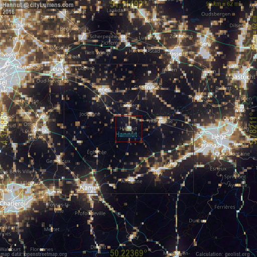
Analysis of Hannut night lights 2016
Square area 10x10 km:
 0.27%
0.27%90-99
0.8%80-89
1.07%70-79
1.6%60-69
2.41%50-59
1.74%40-49
4.68%30-39
1.74%20-29
3.61%10-19
11.9%0-9
70.19%Square area 50x50 km:
1.62%90-99
2.18%80-89
1.41%70-79
1.85%60-69
2.33%50-59
2.69%40-49
4.19%30-39
3.63%20-29
6.41%10-19
22.1%0-9
51.59%Clear (daylight) street map image can be seen on geolist.org.
Map coordinates:
51° 6' 53.7" North, 4° 22' 33.1" East
50° 40' 17.1" North, 5° 4' 44.3" East
50° 13' 25.3" North, 5° 46' 55.6" East
Some cities around Hannut sort by population:
• Landen
9 km =5.6 mi,  1°
1°
• Éghezée
14.8 km =9.2 mi,  232°
232°
• Waremme
12.8 km =8 mi,  76°
76°
• Jodoigne
15.9 km =9.9 mi,  291°
291°
• Gingelom
9.4 km =5.8 mi,  24°
24°
• Villers-le-Bouillet
16.5 km =10.3 mi,  129°
129°
• Ramillies
13.2 km =8.2 mi,  251°
251°
• Braives
7.1 km =4.4 mi,  147°
147°
2796583 (p: 14,129)
Sources (retrieved 2019-11-25):
» Earth at Night: Flat Maps 2012, 2016