Perwez night lights from space
Night Light of Perwez (Wallonia) from space (Belgium) Src. Average luminocity for 10x10km area is 7.0882% and for 50x50km: 23.6051%.
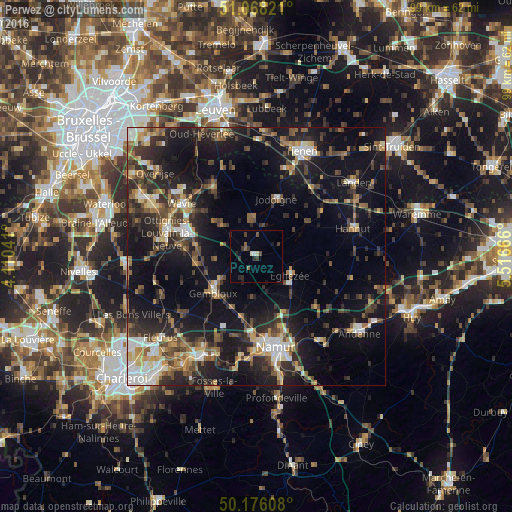
Analysis of Perwez night lights 2016
Square area 10x10 km:
 0.27%
0.27%90-99
0.8%80-89
0.53%70-79
0%60-69
0.13%50-59
1.6%40-49
1.47%30-39
2.81%20-29
2.01%10-19
1.34%0-9
89.04%Square area 50x50 km:
2.49%90-99
3.25%80-89
2.25%70-79
2.66%60-69
3.14%50-59
3.43%40-49
4.83%30-39
4.61%20-29
8.2%10-19
20.16%0-9
44.98%Clear (daylight) street map image can be seen on geolist.org.
Map coordinates:
51° 4' 5.6" North, 4° 6' 37.5" East
50° 37' 27.3" North, 4° 48' 48.7" East
50° 10' 33.9" North, 5° 30' 60" East
Some cities around Perwez sort by population:
• Gembloux
10.7 km =6.6 mi,  229°
229°
• Éghezée
7.9 km =4.9 mi,  118°
118°
• Jodoigne
11.7 km =7.3 mi,  19°
19°
• Chaumont-Gistoux
8.8 km =5.5 mi,  312°
312°
• Mont-Saint-Guibert
14.4 km =8.9 mi,  274°
274°
• Chastre-Villeroux-Blanmont
12.2 km =7.6 mi,  261°
261°
• Walhain-Saint-Paul
8.1 km =5 mi, 271°
• Ramillies
6.3 km =3.9 mi,  80°
80°
2789156 (p: 7,340)
Sources (retrieved 2019-11-25):
» Earth at Night: Flat Maps 2012, 2016