Braine-le-Comte night lights from space
Night Light of Braine-le-Comte (Wallonia) from space (Belgium) Src. Average luminocity for 10x10km area is 27.0615% and for 50x50km: 40.4562%.
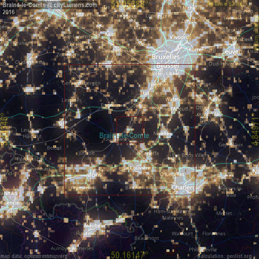

Analysis of Braine-le-Comte night lights 2016
Square area 10x10 km:
 1.34%
1.34%90-99
2.94%80-89
1.47%70-79
2.67%60-69
4.41%50-59
3.07%40-49
5.08%30-39
5.61%20-29
8.56%10-19
56.68%0-9
8.16%Square area 50x50 km:
6.5%90-99
6.61%80-89
4%70-79
5.42%60-69
6.29%50-59
6.78%40-49
6.18%30-39
7.86%20-29
12.46%10-19
23.2%0-9
14.68%Clear (daylight) street map image can be seen on geolist.org.
Map coordinates:
51° 3' 14" North, 3° 26' 36.5" East
50° 36' 35.2" North, 4° 8' 47.7" East
50° 9' 41.3" North, 4° 50' 59" East
Some cities around Braine-le-Comte sort by population:
• Soignies
6.3 km =3.9 mi,  237°
237°
• Tubize
9.8 km =6.1 mi,  23°
23°
• Enghien
11.5 km =7.1 mi,  315°
315°
• Seneffe
12 km =7.5 mi,  136°
136°
• Rebecq-Rognon
5.4 km =3.4 mi,  328°
328°
• Écaussinnes-d’Enghien
4.8 km =3 mi,  163°
163°
• Roeulx
12.1 km =7.5 mi,  191°
191°
• Ittre
9.2 km =5.7 mi,  65°
65°
2801150 (p: 20,133)
Sources (retrieved 2019-11-25):
» Earth at Night: Flat Maps 2012, 2016