Tubize night lights from space
Night Light of Tubize (Wallonia) from space (Belgium) Src. Average luminocity for 10x10km area is 47.139% and for 50x50km: 43.4382%.
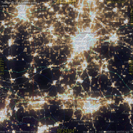
Analysis of Tubize night lights 2016
Square area 10x10 km:
 4.95%
4.95%90-99
4.95%80-89
2.94%70-79
8.96%60-69
8.69%50-59
11.63%40-49
12.43%30-39
11.1%20-29
20.59%10-19
13.5%0-9
0.27%Square area 50x50 km:
9.6%90-99
7.11%80-89
3.75%70-79
4.84%60-69
5.99%50-59
6.81%40-49
6.97%30-39
8.24%20-29
13.27%10-19
20.32%0-9
13.1%Clear (daylight) street map image can be seen on geolist.org.
Map coordinates:
51° 8' 2.1" North, 3° 29' 52" East
50° 41' 26.1" North, 4° 12' 3.2" East
50° 14' 34.9" North, 4° 54' 14.5" East
Some cities around Tubize sort by population:
• Braine-l'Alleud
11.8 km =7.3 mi,  93°
93°
• Halle
5.4 km =3.4 mi,  26°
26°
• Sint-Pieters-Leeuw
10.3 km =6.4 mi,  16°
16°
• Beersel
10.9 km =6.8 mi,  39°
39°
• Braine-le-Comte
9.8 km =6.1 mi,  203°
203°
• Rebecq-Rognon
7.9 km =4.9 mi,  236°
236°
• Braine-le-Château
5.3 km =3.3 mi,  103°
103°
• Ittre
6.9 km =4.3 mi,  139°
139°
2785169 (p: 21,859)
Sources (retrieved 2019-11-25):
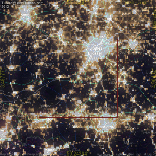
» Earth at Night: Flat Maps 2012, 2016