Hoeilaart night lights from space
Night Light of Hoeilaart (Flanders) from space (Belgium) Src. Average luminocity for 10x10km area is 48.5168% and for 50x50km: 45.0462%.
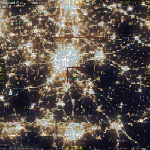
Analysis of Hoeilaart night lights 2016
Square area 10x10 km:
 5.74%
5.74%90-99
5.88%80-89
3.64%70-79
6.3%60-69
9.94%50-59
5.74%40-49
9.1%30-39
23.25%20-29
30.25%10-19
0.14%0-9
0%Square area 50x50 km:
10.13%90-99
7.65%80-89
3.77%70-79
4.89%60-69
6.49%50-59
7.16%40-49
8.24%30-39
8.97%20-29
12.34%10-19
15.71%0-9
14.65%Clear (daylight) street map image can be seen on geolist.org.
Map coordinates:
51° 12' 35.6" North, 3° 45' 54.8" East
50° 46' 2.3" North, 4° 28' 6.1" East
50° 19' 13.7" North, 5° 10' 17.3" East
Some cities around Hoeilaart sort by population:
• Waterloo
7.6 km =4.7 mi,  219°
219°
• Overijse
4.7 km =2.9 mi,  80°
80°
• Rixensart
7.3 km =4.5 mi,  146°
146°
• Tervuren
7.1 km =4.4 mi,  27°
27°
• Sint-Genesius-Rode
8.1 km =5 mi,  253°
253°
• Basse Lasne
8.2 km =5.1 mi,  168°
168°
• Wezembeek-Oppem
8.2 km =5.1 mi,  12°
12°
• La Hulpe
4.2 km =2.6 mi,  163°
163°
2795699 (p: 10,272)
Sources (retrieved 2019-11-25):
» Earth at Night: Flat Maps 2012, 2016