La Hulpe night lights from space
Night Light of La Hulpe (Wallonia) from space (Belgium) Src. Average luminocity for 10x10km area is 44.6992% and for 50x50km: 42.7179%.
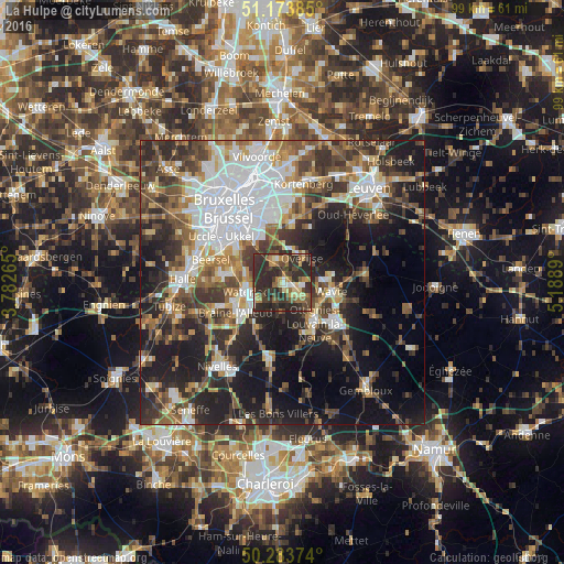
Analysis of La Hulpe night lights 2016
Square area 10x10 km:
 2.14%
2.14%90-99
3.61%80-89
6.82%70-79
6.42%60-69
8.16%50-59
6.15%40-49
9.63%30-39
17.11%20-29
37.97%10-19
2.01%0-9
0%Square area 50x50 km:
9.87%90-99
7.27%80-89
3.52%70-79
4.53%60-69
5.78%50-59
6.22%40-49
7.25%30-39
8.52%20-29
12.09%10-19
17.71%0-9
17.23%Clear (daylight) street map image can be seen on geolist.org.
Map coordinates:
51° 10' 25.9" North, 3° 46' 57.5" East
50° 43' 51.3" North, 4° 29' 8.8" East
50° 17' 1.5" North, 5° 11' 20" East
Some cities around La Hulpe sort by population:
• Wavre
8.3 km =5.2 mi,  100°
100°
• Waterloo
6.4 km =4 mi,  253°
253°
• Overijse
5.9 km =3.7 mi,  35°
35°
• Rixensart
3.5 km =2.2 mi,  126°
126°
• Sint-Genesius-Rode
9.2 km =5.7 mi,  280°
280°
• Basse Lasne
4 km =2.5 mi,  173°
173°
• Hoeilaart
4.2 km =2.6 mi,  343°
343°
• Ottignies
9.3 km =5.8 mi,  141°
141°
2793548 (p: 7,415)
Sources (retrieved 2019-11-25):
» Earth at Night: Flat Maps 2012, 2016