Qarayeri night lights from space
Night Light of Qarayeri (Samux) from space (Azerbaijan) Src. Average luminocity for 10x10km area is 7.8101% and for 50x50km: 6.2532%.
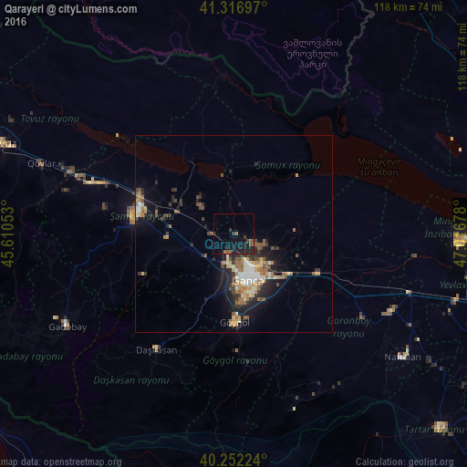
Analysis of Qarayeri night lights 2016
Square area 10x10 km:
 0%
0%90-99
0%80-89
0%70-79
0%60-69
0.81%50-59
3.08%40-49
1.46%30-39
1.3%20-29
4.87%10-19
12.34%0-9
76.14%Square area 50x50 km:
0.67%90-99
0.75%80-89
0.68%70-79
0.83%60-69
1.05%50-59
1.19%40-49
0.9%30-39
0.83%20-29
2.25%10-19
4.06%0-9
86.78%Clear (daylight) street map image can be seen on geolist.org.
Map coordinates:
41° 19' 1.1" North, 45° 36' 37.9" East
40° 47' 12.3" North, 46° 18' 49.1" East
40° 15' 8.1" North, 47° 1' 0.4" East
Some cities around Qarayeri sort by population:
• Ganja
12.2 km =7.6 mi,  161°
161°
• Shamkhor
25.4 km =15.8 mi,  280°
280°
• Yelenendorf
22.3 km =13.9 mi,  178°
178°
• Yukhary-Dashkesan
35.2 km =21.9 mi,  213°
213°
• Kyadabek
48.6 km =30.2 mi,  240°
240°
• Dzagam
38.3 km =23.8 mi,  289°
289°
• Goranboy
44.7 km =27.8 mi,  116°
116°
• Samux
8.4 km =5.2 mi,  106°
106°
586135 (p: 5,565)
Sources (retrieved 2019-11-25):
» Earth at Night: Flat Maps 2012, 2016