Dzagam night lights from space
Night Light of Dzagam (Şǝmkir) from space (Azerbaijan) Src. Average luminocity for 10x10km area is 9.7364% and for 50x50km: 2.2996%.
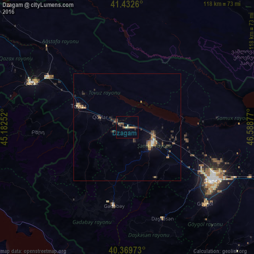
Analysis of Dzagam night lights 2016
Square area 10x10 km:
 0%
0%90-99
0.34%80-89
1.02%70-79
1.87%60-69
1.87%50-59
3.06%40-49
2.04%30-39
2.04%20-29
1.36%10-19
2.21%0-9
84.18%Square area 50x50 km:
0.07%90-99
0.08%80-89
0.2%70-79
0.29%60-69
0.49%50-59
0.6%40-49
0.43%30-39
0.53%20-29
0.68%10-19
1.1%0-9
95.52%Clear (daylight) street map image can be seen on geolist.org.
Map coordinates:
41° 25' 57.4" North, 45° 10' 57.1" East
40° 54' 11.9" North, 45° 53' 8.3" East
40° 22' 11" North, 46° 35' 19.6" East
Some cities around Dzagam sort by population:
• Shamkhor
13.8 km =8.6 mi,  126°
126°
• Tovuz
23.8 km =14.8 mi,  294°
294°
• Aghstafa
43.4 km =27 mi,  303°
303°
• Yukhary-Dashkesan
45.3 km =28.1 mi,  158°
158°
• Kyadabek
37.5 km =23.3 mi,  189°
189°
• Berd, AM
41.8 km =26 mi,  266°
266°
• Samux
46.6 km =29 mi,  109°
109°
• Qarayeri
38.3 km =23.8 mi, 109°
586692 (p: 7,442)
Sources (retrieved 2019-11-25):
» Earth at Night: Flat Maps 2012, 2016