Goranboy night lights from space
Night Light of Goranboy from space (Azerbaijan) Src. Average luminocity for 10x10km area is 5.6023% and for 50x50km: 2.4612%.
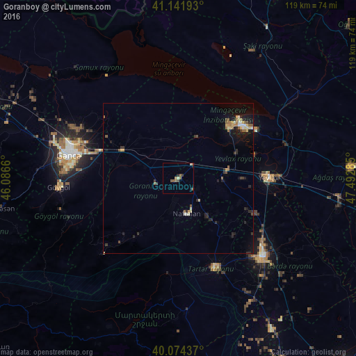
Analysis of Goranboy night lights 2016
Square area 10x10 km:
100  0%
0%
90-99 0.97%
80-89 0.32%
70-79 0%
60-69 0.97%
50-59 3.41%
40-49 0.81%
30-39 0.65%
20-29 0.97%
10-19 0.65%
0-9 91.23%
0%90-99
0.97%80-89
0.32%70-79
0%60-69
0.97%50-59
3.41%40-49
0.81%30-39
0.65%20-29
0.97%10-19
0.65%0-9
91.23%Square area 50x50 km:
100 0.12%
90-99 0.28%
80-89 0.4%
70-79 0.18%
60-69 0.33%
50-59 0.55%
40-49 0.25%
30-39 0.4%
20-29 0.76%
10-19 1.85%
0-9 94.87%
0.12%90-99
0.28%80-89
0.4%70-79
0.18%60-69
0.33%50-59
0.55%40-49
0.25%30-39
0.4%20-29
0.76%10-19
1.85%0-9
94.87%Clear (daylight) street map image can be seen on geolist.org.
Map coordinates:
41° 8' 30.9" North, 46° 5' 11.8" East
40° 36' 37" North, 46° 47' 23" East
40° 4' 27.7" North, 47° 29' 34.3" East
Some cities around Goranboy sort by population:
• Ganja
37.1 km =23.1 mi,  282°
282°
• Yevlakh
30.4 km =18.9 mi,  88°
88°
• Mingelchaur
28.5 km =17.7 mi,  53°
53°
• Terter
32.2 km =20 mi,  158°
158°
• Naftalan
11.6 km =7.2 mi,  167°
167°
• Aran
15.8 km =9.8 mi,  83°
83°
• Qızılhacılı
6.8 km =4.2 mi,  122°
122°
• Samux
36.4 km =22.6 mi,  298°
298°
586430 (p: 7,333)
Sources (retrieved 2019-11-25):
» Earth at Night: Flat Maps 2012, 2016