Balakhani night lights from space
Night Light of Balakhani (Baki) from space (Azerbaijan) Src. Average luminocity for 10x10km area is 78.6735% and for 50x50km: 37.4797%.
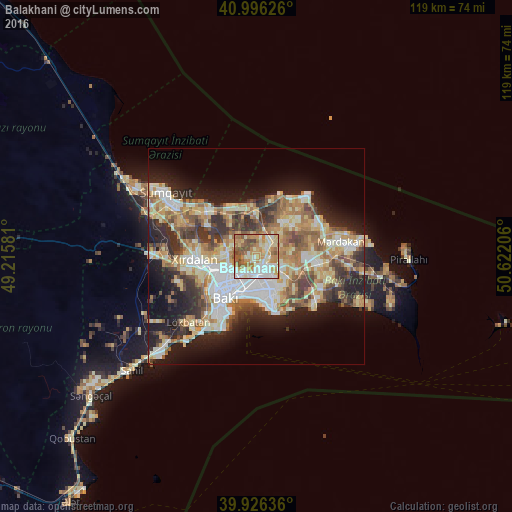
Analysis of Balakhani night lights 2016
Square area 10x10 km:
 14.12%
90-99
20.41%80-89
16.5%70-79
17.35%60-69
14.46%50-59
10.03%40-49
6.63%30-39
0.51%20-29
0%10-19
0%0-9
0%Square area 50x50 km:
6.34%90-99
7.29%80-89
5.92%70-79
5.59%60-69
6.53%50-59
4.99%40-49
4.64%30-39
5.42%20-29
7.42%10-19
12.26%0-9
33.6%Clear (daylight) street map image can be seen on geolist.org.
Map coordinates:
40° 59' 46.5" North, 49° 12' 56.9" East
40° 27' 48.4" North, 49° 55' 8.1" East
39° 55' 34.9" North, 50° 37' 19.4" East
Some cities around Balakhani sort by population:
• Baku
9.8 km =6.1 mi,  193°
193°
• Qaraçuxur
8.7 km =5.4 mi,  148°
148°
• Bakıxanov
6.4 km =4 mi,  140°
140°
• Amirdzhan
6.9 km =4.3 mi,  126°
126°
• Zabrat
2.5 km =1.6 mi,  51°
51°
• Sabunçu
3.4 km =2.1 mi, 133°
• Binagadi
7.7 km =4.8 mi,  272°
272°
• Ramana
5.7 km =3.5 mi,  114°
114°
587071 (p: 10,863)
Sources (retrieved 2019-11-25):
» Earth at Night: Flat Maps 2012, 2016