West Pymble night lights from space
Night Light of West Pymble (New South Wales) from space (Australia) Src. Average luminocity for 10x10km area is 75.8462% and for 50x50km: 46.0898%.
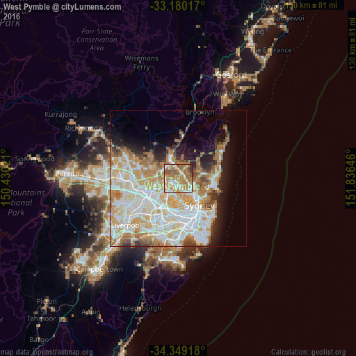
Analysis of West Pymble night lights 2016
Square area 10x10 km:
 9.16%
9.16%90-99
18.13%80-89
8.79%70-79
21.79%60-69
29.12%50-59
9.71%40-49
1.28%30-39
2.01%20-29
0%10-19
0%0-9
0%Square area 50x50 km:
11.49%90-99
12.6%80-89
6.51%70-79
7.54%60-69
7.88%50-59
3.42%40-49
2.17%30-39
2.82%20-29
3.79%10-19
6.6%0-9
35.17%Clear (daylight) street map image can be seen on geolist.org.
Map coordinates:
33° 10' 48.6" South, 150° 25' 48.8" East
33° 46' 0" South, 151° 7' 60" East
34° 20' 57" South, 151° 50' 11.3" East
Some cities around West Pymble sort by population:
• Marsfield
2.8 km =1.7 mi,  244°
244°
• Turramurra
3.7 km =2.3 mi,  353°
353°
• Pymble
2.7 km =1.7 mi,  17°
17°
• North Ryde
3.4 km =2.1 mi,  193°
193°
• Killara
2.7 km =1.7 mi,  88°
88°
• Lindfield
3.6 km =2.2 mi,  121°
121°
• Macquarie Park
1.7 km =1.1 mi,  198°
198°
• Gordon
2.1 km =1.3 mi,  52°
52°
2143954 (p: 5,211)
Sources (retrieved 2019-11-25):
» Earth at Night: Flat Maps 2012, 2016