Turramurra night lights from space
Night Light of Turramurra (New South Wales) from space (Australia) Src. Average luminocity for 10x10km area is 65.7436% and for 50x50km: 43.1277%.
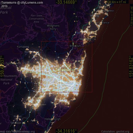
Analysis of Turramurra night lights 2016
Square area 10x10 km:
 7.14%
7.14%90-99
10.81%80-89
4.4%70-79
12.64%60-69
35.53%50-59
13.37%40-49
3.66%30-39
3.85%20-29
6.96%10-19
1.65%0-9
0%Square area 50x50 km:
10.8%90-99
11.77%80-89
6.46%70-79
7.3%60-69
7.1%50-59
2.79%40-49
1.74%30-39
2.31%20-29
3.49%10-19
6.55%0-9
39.68%Clear (daylight) street map image can be seen on geolist.org.
Map coordinates:
33° 8' 48.1" South, 150° 25' 31.3" East
33° 44' 0.3" South, 151° 7' 42.6" East
34° 18' 58.2" South, 151° 49' 53.8" East
Some cities around Turramurra sort by population:
• Hornsby
4.4 km =2.7 mi,  321°
321°
• Wahroonga
2.1 km =1.3 mi, 324°
• Saint Ives
2.9 km =1.8 mi,  81°
81°
• Pymble
1.7 km =1.1 mi,  133°
133°
• Gordon
3.2 km =2 mi,  139°
139°
• Waitara
3.4 km =2.1 mi, 317°
• West Pymble
3.7 km =2.3 mi,  173°
173°
• Normanhurst
3.2 km =2 mi,  289°
289°
2145796 (p: 11,690)
Sources (retrieved 2019-11-25):
» Earth at Night: Flat Maps 2012, 2016