Macquarie Park night lights from space
Night Light of Macquarie Park (New South Wales) from space (Australia) Src. Average luminocity for 10x10km area is 79.011% and for 50x50km: 47.7712%.
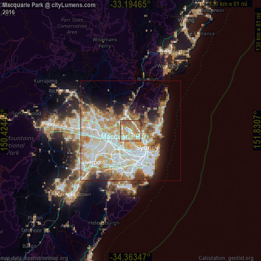
Analysis of Macquarie Park night lights 2016
Square area 10x10 km:
 11.72%
90-99
20.88%80-89
9.34%70-79
25.64%60-69
24.73%50-59
7.33%40-49
0%30-39
0.37%20-29
0%10-19
0%0-9
0%Square area 50x50 km:
11.62%90-99
12.77%80-89
6.73%70-79
7.85%60-69
8.31%50-59
3.92%40-49
2.31%30-39
3.22%20-29
4.57%10-19
6.94%0-9
31.75%Clear (daylight) street map image can be seen on geolist.org.
Map coordinates:
33° 11' 40.7" South, 150° 25' 28" East
33° 46' 51.8" South, 151° 7' 39.3" East
34° 21' 48.5" South, 151° 49' 50.5" East
Some cities around Macquarie Park sort by population:
• Epping
4.3 km =2.7 mi,  282°
282°
• Marsfield
2 km =1.2 mi, 280°
• Pymble
4.3 km =2.7 mi,  17°
17°
• North Ryde
1.8 km =1.1 mi,  189°
189°
• Killara
3.6 km =2.2 mi,  62°
62°
• Lindfield
3.6 km =2.2 mi,  94°
94°
• Gordon
3.6 km =2.2 mi,  37°
37°
• West Pymble
1.7 km =1.1 mi, 18°
8347858 (p: 9,054)
Sources (retrieved 2019-11-25):
» Earth at Night: Flat Maps 2012, 2016