Pymble night lights from space
Night Light of Pymble (New South Wales) from space (Australia) Src. Average luminocity for 10x10km area is 67.793% and for 50x50km: 43.3086%.
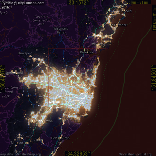
Analysis of Pymble night lights 2016
Square area 10x10 km:
 6.78%
6.78%90-99
11.36%80-89
4.95%70-79
13.92%60-69
36.45%50-59
12.64%40-49
4.58%30-39
5.86%20-29
3.3%10-19
0.18%0-9
0%Square area 50x50 km:
11.05%90-99
12%80-89
6.41%70-79
7.04%60-69
7.04%50-59
2.9%40-49
1.64%30-39
2.27%20-29
3.55%10-19
6.44%0-9
39.65%Clear (daylight) street map image can be seen on geolist.org.
Map coordinates:
33° 9' 25.9" South, 150° 26' 19.5" East
33° 44' 37.9" South, 151° 8' 30.8" East
34° 19' 35.5" South, 151° 50' 42" East
Some cities around Pymble sort by population:
• Wahroonga
3.8 km =2.4 mi,  319°
319°
• Saint Ives
2.3 km =1.4 mi,  46°
46°
• Turramurra
1.7 km =1.1 mi,  313°
313°
• Killara
3.1 km =1.9 mi,  142°
142°
• Macquarie Park
4.3 km =2.7 mi,  197°
197°
• Gordon
1.5 km =0.9 mi,  146°
146°
• Normanhurst
4.8 km =3 mi,  297°
297°
• West Pymble
2.7 km =1.7 mi, 197°
2152361 (p: 10,932)
Sources (retrieved 2019-11-25):
» Earth at Night: Flat Maps 2012, 2016