Wattle Grove night lights from space
Night Light of Wattle Grove (New South Wales) from space (Australia) Src. Average luminocity for 10x10km area is 70.0577% and for 50x50km: 51.1274%.
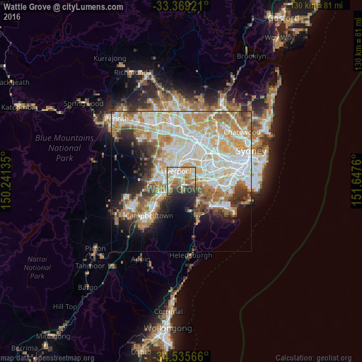
Analysis of Wattle Grove night lights 2016
Square area 10x10 km:
 13.29%
90-99
17.13%80-89
11.01%70-79
12.76%60-69
12.06%50-59
11.54%40-49
5.94%30-39
5.94%20-29
10.31%10-19
0%0-9
0%Square area 50x50 km:
12.44%90-99
13.36%80-89
7.12%70-79
8.21%60-69
8.59%50-59
4.59%40-49
3.07%30-39
4.27%20-29
4.67%10-19
7.56%0-9
26.11%Clear (daylight) street map image can be seen on geolist.org.
Map coordinates:
33° 22' 9.2" South, 150° 14' 28.9" East
33° 57' 15.9" South, 150° 56' 40.1" East
34° 32' 8.4" South, 151° 38' 51.4" East
Some cities around Wattle Grove sort by population:
• Liverpool
4.3 km =2.7 mi,  336°
336°
• Casula
4.2 km =2.6 mi,  273°
273°
• Panania
4.9 km =3 mi,  88°
88°
• Moorebank
1.6 km =1 mi,  43°
43°
• Glenfield
4.3 km =2.7 mi,  251°
251°
• Chipping Norton
4.3 km =2.7 mi,  18°
18°
• Warwick Farm
4.7 km =2.9 mi,  351°
351°
• Holsworthy
3.8 km =2.4 mi,  147°
147°
8349338 (p: 8,885)
Sources (retrieved 2019-11-25):
» Earth at Night: Flat Maps 2012, 2016