Holsworthy night lights from space
Night Light of Holsworthy (New South Wales) from space (Australia) Src. Average luminocity for 10x10km area is 47.7238% and for 50x50km: 47.3281%.
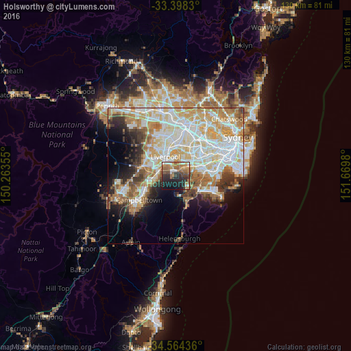
Analysis of Holsworthy night lights 2016
Square area 10x10 km:
 5.42%
5.42%90-99
5.07%80-89
3.15%70-79
9.44%60-69
13.29%50-59
11.19%40-49
6.64%30-39
9.09%20-29
17.66%10-19
17.83%0-9
1.22%Square area 50x50 km:
12.06%90-99
12.4%80-89
6.42%70-79
7.17%60-69
7.28%50-59
4.31%40-49
2.88%30-39
4.27%20-29
4.74%10-19
7.22%0-9
31.25%Clear (daylight) street map image can be seen on geolist.org.
Map coordinates:
33° 23' 53.9" South, 150° 15' 48.8" East
33° 58' 60" South, 150° 58' 0" East
34° 33' 51.7" South, 151° 40' 11.3" East
Some cities around Holsworthy sort by population:
• Revesby
5.9 km =3.7 mi,  51°
51°
• Panania
4.3 km =2.7 mi,  40°
40°
• Menai
5.9 km =3.7 mi,  128°
128°
• Moorebank
4.5 km =2.8 mi,  348°
348°
• Glenfield
6.4 km =4 mi,  286°
286°
• Wattle Grove
3.8 km =2.4 mi,  327°
327°
• Illawong
6.4 km =4 mi,  106°
106°
• Picnic Point
2.8 km =1.7 mi,  83°
83°
2163270 (p: 5,771)
Sources (retrieved 2019-11-25):
» Earth at Night: Flat Maps 2012, 2016