Glenfield night lights from space
Night Light of Glenfield (New South Wales) from space (Australia) Src. Average luminocity for 10x10km area is 72.799% and for 50x50km: 45.5293%.
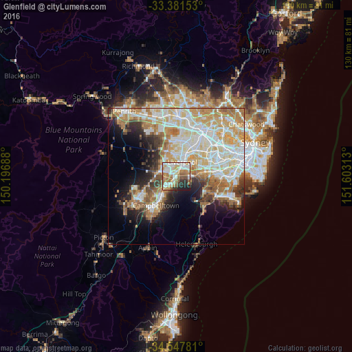
Analysis of Glenfield night lights 2016
Square area 10x10 km:
 17.48%
90-99
20.63%80-89
11.01%70-79
8.22%60-69
14.16%50-59
10.14%40-49
2.97%30-39
3.85%20-29
7.87%10-19
3.67%0-9
0%Square area 50x50 km:
10.31%90-99
11.93%80-89
6.49%70-79
7.44%60-69
7.64%50-59
4.22%40-49
2.79%30-39
3.96%20-29
4.54%10-19
7.69%0-9
32.99%Clear (daylight) street map image can be seen on geolist.org.
Map coordinates:
33° 22' 53.5" South, 150° 11' 48.8" East
33° 58' 0" South, 150° 54' 0" East
34° 32' 52.1" South, 151° 36' 11.3" East
Some cities around Glenfield sort by population:
• Liverpool
5.8 km =3.6 mi,  24°
24°
• Casula
1.6 km =1 mi,  358°
358°
• Prestons
3.8 km =2.4 mi,  316°
316°
• Ingleburn
4.8 km =3 mi,  219°
219°
• Macquarie Fields
2.9 km =1.8 mi,  192°
192°
• Moorebank
5.8 km =3.6 mi,  63°
63°
• Lurnea
3.5 km =2.2 mi, 355°
• Wattle Grove
4.3 km =2.7 mi,  71°
71°
2165326 (p: 9,538)
Sources (retrieved 2019-11-25):
» Earth at Night: Flat Maps 2012, 2016