Chipping Norton night lights from space
Night Light of Chipping Norton (New South Wales) from space (Australia) Src. Average luminocity for 10x10km area is 87.0542% and for 50x50km: 56.6984%.
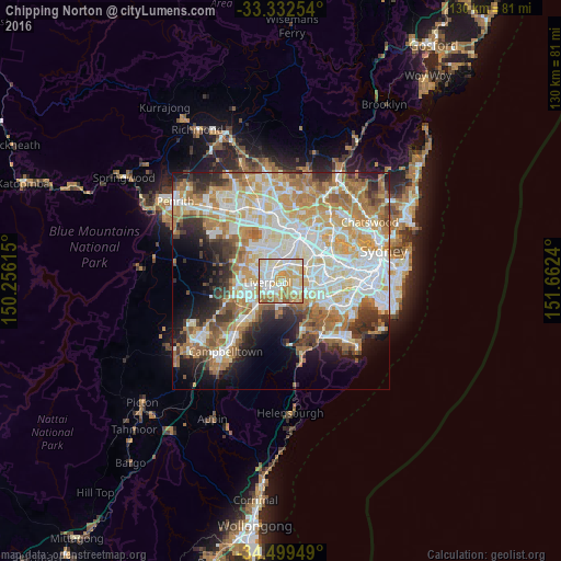
Analysis of Chipping Norton night lights 2016
Square area 10x10 km:
 22.73%
90-99
27.1%80-89
20.45%70-79
18.36%60-69
7.17%50-59
4.2%40-49
0%30-39
0%20-29
0%10-19
0%0-9
0%Square area 50x50 km:
13.34%90-99
14.22%80-89
7.74%70-79
9.29%60-69
10.42%50-59
5.58%40-49
3.64%30-39
5.17%20-29
5.79%10-19
7.71%0-9
17.1%Clear (daylight) street map image can be seen on geolist.org.
Map coordinates:
33° 19' 57.1" South, 150° 15' 22.1" East
33° 55' 4.8" South, 150° 57' 33.4" East
34° 29' 58.2" South, 151° 39' 44.6" East
Some cities around Chipping Norton sort by population:
• Liverpool
3.1 km =1.9 mi,  267°
267°
• Cabramatta
3.2 km =2 mi,  314°
314°
• Canley Vale
3.6 km =2.2 mi,  343°
343°
• Moorebank
2.9 km =1.8 mi,  184°
184°
• Bass Hill
4 km =2.5 mi,  57°
57°
• Georges Hall
2.9 km =1.8 mi,  69°
69°
• Villawood
4.2 km =2.6 mi,  27°
27°
• Warwick Farm
2.1 km =1.3 mi,  285°
285°
2171586 (p: 8,981)
Sources (retrieved 2019-11-25):
» Earth at Night: Flat Maps 2012, 2016