Casula night lights from space
Night Light of Casula (New South Wales) from space (Australia) Src. Average luminocity for 10x10km area is 80.0367% and for 50x50km: 48.236%.
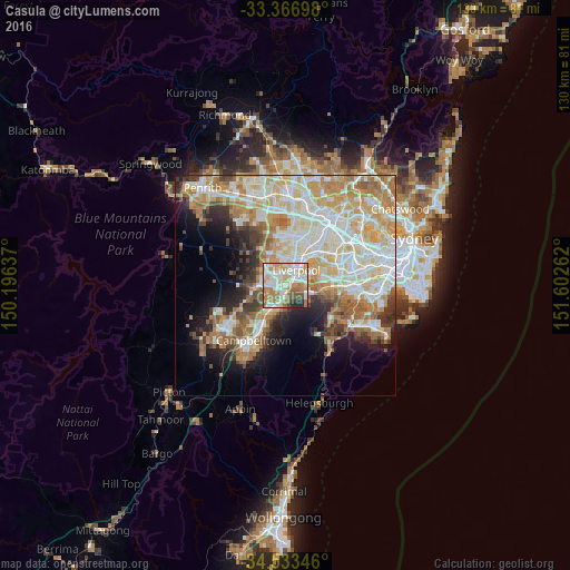
Analysis of Casula night lights 2016
Square area 10x10 km:
 19.93%
90-99
25.17%80-89
12.24%70-79
11.54%60-69
13.81%50-59
8.74%40-49
2.97%30-39
2.27%20-29
3.32%10-19
0%0-9
0%Square area 50x50 km:
10.88%90-99
12.6%80-89
6.99%70-79
8.06%60-69
8.21%50-59
4.41%40-49
2.93%30-39
4.16%20-29
4.59%10-19
7.76%0-9
29.42%Clear (daylight) street map image can be seen on geolist.org.
Map coordinates:
33° 22' 1.1" South, 150° 11' 46.9" East
33° 57' 8" South, 150° 53' 58.2" East
34° 32' 0.5" South, 151° 36' 9.4" East
Some cities around Casula sort by population:
• Liverpool
4.4 km =2.7 mi,  33°
33°
• Prestons
2.8 km =1.7 mi,  294°
294°
• Macquarie Fields
4.5 km =2.8 mi,  187°
187°
• Hinchinbrook
5 km =3.1 mi,  317°
317°
• Moorebank
5.3 km =3.3 mi,  79°
79°
• Glenfield
1.6 km =1 mi,  178°
178°
• Lurnea
1.9 km =1.2 mi,  352°
352°
• Wattle Grove
4.2 km =2.6 mi,  93°
93°
8348477 (p: 15,695)
Sources (retrieved 2019-11-25):
» Earth at Night: Flat Maps 2012, 2016