Moorebank night lights from space
Night Light of Moorebank (New South Wales) from space (Australia) Src. Average luminocity for 10x10km area is 76.028% and for 50x50km: 53.7958%.
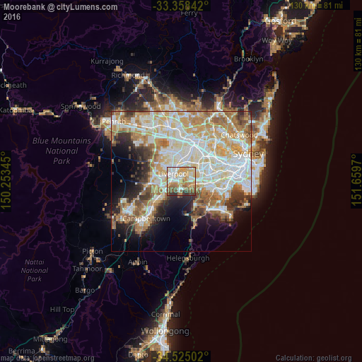
Analysis of Moorebank night lights 2016
Square area 10x10 km:
 15.21%
90-99
19.23%80-89
11.71%70-79
18.18%60-69
11.89%50-59
11.89%40-49
5.42%30-39
5.07%20-29
1.4%10-19
0%0-9
0%Square area 50x50 km:
13.08%90-99
13.87%80-89
7.48%70-79
8.79%60-69
9.35%50-59
4.99%40-49
3.2%30-39
4.51%20-29
4.83%10-19
7.27%0-9
22.64%Clear (daylight) street map image can be seen on geolist.org.
Map coordinates:
33° 21' 30.3" South, 150° 15' 12.4" East
33° 56' 37.4" South, 150° 57' 23.7" East
34° 31' 30.1" South, 151° 39' 34.9" East
Some cities around Moorebank sort by population:
• Liverpool
3.9 km =2.4 mi,  313°
313°
• Casula
5.3 km =3.3 mi,  259°
259°
• Panania
3.9 km =2.4 mi,  106°
106°
• Georges Hall
4.9 km =3 mi,  37°
37°
• Chipping Norton
2.9 km =1.8 mi,  4°
4°
• Wattle Grove
1.6 km =1 mi,  223°
223°
• Warwick Farm
3.9 km =2.4 mi,  332°
332°
• Holsworthy
4.5 km =2.8 mi,  168°
168°
8347678 (p: 9,621)
Sources (retrieved 2019-11-25):
» Earth at Night: Flat Maps 2012, 2016