Warnbro night lights from space
Night Light of Warnbro (Western Australia) from space (Australia) Src. Average luminocity for 10x10km area is 40.293% and for 50x50km: 15.8954%.
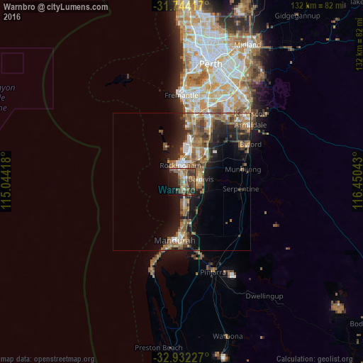
Analysis of Warnbro night lights 2016
Square area 10x10 km:
 1.1%
1.1%90-99
2.56%80-89
2.75%70-79
4.21%60-69
11.9%50-59
17.03%40-49
9.89%30-39
11.54%20-29
11.54%10-19
18.5%0-9
8.97%Square area 50x50 km:
1.74%90-99
1.72%80-89
1.24%70-79
1.41%60-69
5.07%50-59
3.95%40-49
2.55%30-39
2.77%20-29
4.14%10-19
9.01%0-9
66.39%Clear (daylight) street map image can be seen on geolist.org.
Map coordinates:
31° 44' 39" South, 115° 2' 39" East
32° 20' 24.6" South, 115° 44' 50.3" East
32° 55' 56.2" South, 116° 27' 1.5" East
Some cities around Warnbro sort by population:
• Rockingham
7.2 km =4.5 mi,  346°
346°
• Baldivis
7.9 km =4.9 mi,  80°
80°
• Rockingham city centre
6.3 km =3.9 mi, 349°
• Port Kennedy
3.7 km =2.3 mi,  173°
173°
• Waikiki
2.8 km =1.7 mi,  14°
14°
• Secret Harbour
7.4 km =4.6 mi, 171°
• Safety Bay
4 km =2.5 mi, 352°
• Cooloongup
4 km =2.5 mi,  45°
45°
2079183 (p: 10,426)
Sources (retrieved 2019-11-25):
» Earth at Night: Flat Maps 2012, 2016