Waikiki night lights from space
Night Light of Waikiki (Western Australia) from space (Australia) Src. Average luminocity for 10x10km area is 53.478% and for 50x50km: 17.5442%.
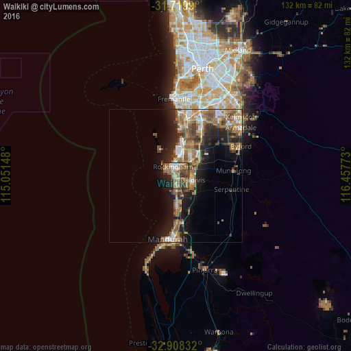
Analysis of Waikiki night lights 2016
Square area 10x10 km:
 6.96%
6.96%90-99
7.33%80-89
2.93%70-79
4.58%60-69
17.95%50-59
18.5%40-49
11.36%30-39
9.34%20-29
6.78%10-19
12.27%0-9
2.01%Square area 50x50 km:
2.19%90-99
2.21%80-89
1.34%70-79
1.77%60-69
5.45%50-59
4.19%40-49
2.72%30-39
2.69%20-29
4.18%10-19
8.8%0-9
64.47%Clear (daylight) street map image can be seen on geolist.org.
Map coordinates:
31° 43' 11.6" South, 115° 3' 5.3" East
32° 18' 57.8" South, 115° 45' 16.6" East
32° 54' 30" South, 116° 27' 27.8" East
Some cities around Waikiki sort by population:
• Rockingham
4.9 km =3 mi,  331°
331°
• Baldivis
7.3 km =4.5 mi,  101°
101°
• Rockingham city centre
4 km =2.5 mi, 333°
• Port Kennedy
6.4 km =4 mi,  182°
182°
• Warnbro
2.8 km =1.7 mi,  194°
194°
• Safety Bay
1.7 km =1.1 mi,  317°
317°
• Cooloongup
2.2 km =1.4 mi,  87°
87°
• Parmelia
9.1 km =5.7 mi,  44°
44°
8349111 (p: 12,008)
Sources (retrieved 2019-11-25):
» Earth at Night: Flat Maps 2012, 2016