Secret Harbour night lights from space
Night Light of Secret Harbour (Western Australia) from space (Australia) Src. Average luminocity for 10x10km area is 29.4359% and for 50x50km: 12.738%.
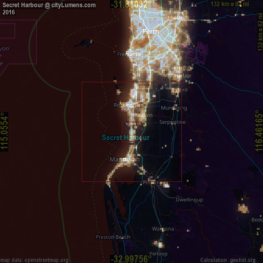
Analysis of Secret Harbour night lights 2016
Square area 10x10 km:
 1.1%
1.1%90-99
1.83%80-89
1.83%70-79
2.01%60-69
9.16%50-59
9.89%40-49
3.48%30-39
5.31%20-29
10.62%10-19
37.91%0-9
16.85%Square area 50x50 km:
1.24%90-99
1.21%80-89
0.8%70-79
1.03%60-69
3.98%50-59
3.13%40-49
1.93%30-39
2.51%20-29
3.06%10-19
9.46%0-9
71.65%Clear (daylight) street map image can be seen on geolist.org.
Map coordinates:
31° 48' 37.2" South, 115° 3' 19.4" East
32° 24' 21.2" South, 115° 45' 30.7" East
32° 59' 51.2" South, 116° 27' 41.9" East
Some cities around Secret Harbour sort by population:
• Baldivis
10.9 km =6.8 mi,  38°
38°
• Port Kennedy
3.7 km =2.3 mi,  349°
349°
• Waikiki
10 km =6.2 mi,  357°
357°
• Warnbro
7.4 km =4.6 mi, 351°
• Greenfields
13.2 km =8.2 mi,  178°
178°
• Meadow Springs
10.2 km =6.3 mi, 182°
• Safety Bay
11.4 km =7.1 mi, 352°
• Cooloongup
10.3 km =6.4 mi,  10°
10°
8349100 (p: 11,551)
Sources (retrieved 2019-11-25):
» Earth at Night: Flat Maps 2012, 2016