Port Kennedy night lights from space
Night Light of Port Kennedy (Western Australia) from space (Australia) Src. Average luminocity for 10x10km area is 33.2875% and for 50x50km: 13.9767%.
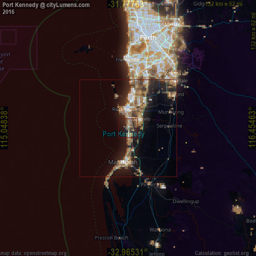
Analysis of Port Kennedy night lights 2016
Square area 10x10 km:
 1.1%
1.1%90-99
2.56%80-89
2.56%70-79
3.11%60-69
9.89%50-59
9.89%40-49
6.96%30-39
7.88%20-29
10.99%10-19
30.77%0-9
14.29%Square area 50x50 km:
1.39%90-99
1.33%80-89
0.91%70-79
1.12%60-69
4.26%50-59
3.57%40-49
2.23%30-39
2.84%20-29
3.98%10-19
9.8%0-9
68.57%Clear (daylight) street map image can be seen on geolist.org.
Map coordinates:
31° 46' 39.5" South, 115° 2' 54.2" East
32° 22' 24.3" South, 115° 45' 5.4" East
32° 57' 55.1" South, 116° 27' 16.7" East
Some cities around Port Kennedy sort by population:
• Rockingham
10.9 km =6.8 mi,  349°
349°
• Baldivis
8.9 km =5.5 mi,  56°
56°
• Rockingham city centre
10 km =6.2 mi, 351°
• Waikiki
6.4 km =4 mi,  2°
2°
• Secret Harbour
3.7 km =2.3 mi,  169°
169°
• Warnbro
3.7 km =2.3 mi, 353°
• Safety Bay
7.7 km =4.8 mi, 353°
• Cooloongup
6.9 km =4.3 mi,  20°
20°
8349098 (p: 13,238)
Sources (retrieved 2019-11-25):
» Earth at Night: Flat Maps 2012, 2016