Safety Bay night lights from space
Night Light of Safety Bay (Western Australia) from space (Australia) Src. Average luminocity for 10x10km area is 50.5% and for 50x50km: 17.7943%.
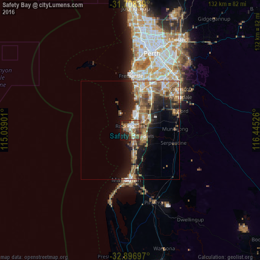
Analysis of Safety Bay night lights 2016
Square area 10x10 km:
 7.14%
7.14%90-99
8.24%80-89
1.83%70-79
4.4%60-69
16.48%50-59
15.93%40-49
8.42%30-39
7.69%20-29
8.61%10-19
15.75%0-9
5.49%Square area 50x50 km:
2.26%90-99
2.26%80-89
1.39%70-79
2.09%60-69
5.47%50-59
4.06%40-49
2.67%30-39
2.63%20-29
4.24%10-19
8.56%0-9
64.38%Clear (daylight) street map image can be seen on geolist.org.
Map coordinates:
31° 42' 30.2" South, 115° 2' 20.4" East
32° 18' 16.7" South, 115° 44' 31.7" East
32° 53' 49.1" South, 116° 26' 42.9" East
Some cities around Safety Bay sort by population:
• Rockingham
3.3 km =2.1 mi,  339°
339°
• Baldivis
8.7 km =5.4 mi,  108°
108°
• Kwinana
9.1 km =5.7 mi,  23°
23°
• Rockingham city centre
2.4 km =1.5 mi, 344°
• Port Kennedy
7.7 km =4.8 mi,  173°
173°
• Waikiki
1.7 km =1.1 mi,  137°
137°
• Warnbro
4 km =2.5 mi, 172°
• Cooloongup
3.5 km =2.2 mi, 109°
2062057 (p: 7,121)
Sources (retrieved 2019-11-25):
» Earth at Night: Flat Maps 2012, 2016