Teneriffe night lights from space
Night Light of Teneriffe (Queensland) from space (Australia) Src. Average luminocity for 10x10km area is 96.0615% and for 50x50km: 44.6298%.
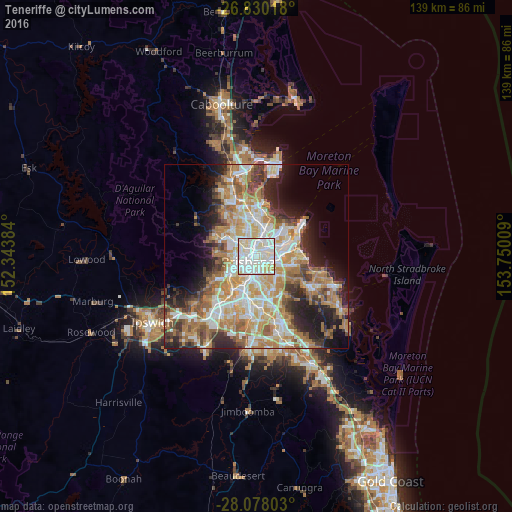
Analysis of Teneriffe night lights 2016
Square area 10x10 km:
 39.09%
90-99
43.45%80-89
14.88%70-79
2.58%60-69
0%50-59
0%40-49
0%30-39
0%20-29
0%10-19
0%0-9
0%Square area 50x50 km:
8.89%90-99
9.58%80-89
5.65%70-79
6.31%60-69
11.68%50-59
4.14%40-49
4.56%30-39
4.73%20-29
7.11%10-19
9.25%0-9
28.11%Clear (daylight) street map image can be seen on geolist.org.
Map coordinates:
26° 49' 48.6" South, 152° 20' 37.8" East
27° 27' 21.1" South, 153° 2' 49.1" East
28° 4' 40.9" South, 153° 45' 0.3" East
Some cities around Teneriffe sort by population:
• Brisbane
2.3 km =1.4 mi,  234°
234°
• New Farm
1.3 km =0.8 mi,  174°
174°
• Kangaroo Point
2.5 km =1.6 mi,  203°
203°
• Fortitude Valley
1.5 km =0.9 mi,  264°
264°
• Spring Hill
2.4 km =1.5 mi, 255°
• Hamilton
2.4 km =1.5 mi,  39°
39°
• Bulimba
1.2 km =0.7 mi,  57°
57°
• East Brisbane
2.8 km =1.7 mi,  185°
185°
8348131 (p: 5,067)
Sources (retrieved 2019-11-25):
» Earth at Night: Flat Maps 2012, 2016