Kangaroo Point night lights from space
Night Light of Kangaroo Point (Queensland) from space (Australia) Src. Average luminocity for 10x10km area is 94.4187% and for 50x50km: 45.615%.
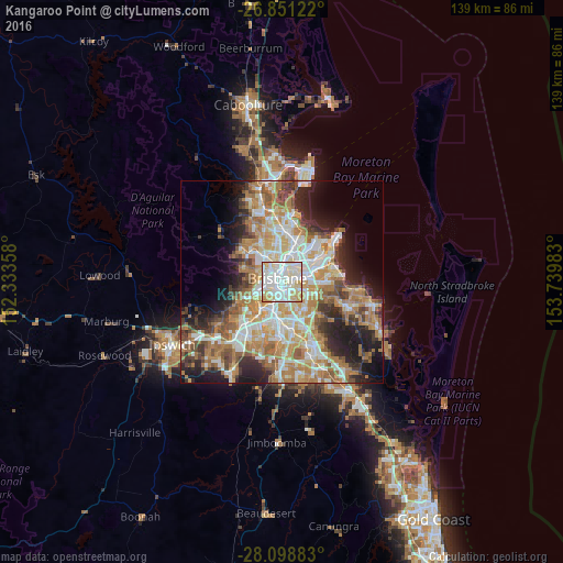
Analysis of Kangaroo Point night lights 2016
Square area 10x10 km:
 35.91%
90-99
40.28%80-89
15.87%70-79
7.54%60-69
0.4%50-59
0%40-49
0%30-39
0%20-29
0%10-19
0%0-9
0%Square area 50x50 km:
8.89%90-99
9.64%80-89
5.73%70-79
6.44%60-69
12.3%50-59
4.34%40-49
4.71%30-39
4.7%20-29
7.54%10-19
9.98%0-9
25.73%Clear (daylight) street map image can be seen on geolist.org.
Map coordinates:
26° 51' 4.4" South, 152° 20' 0.9" East
27° 28' 36.4" South, 153° 2' 12.1" East
28° 5' 55.8" South, 153° 44' 23.4" East
Some cities around Kangaroo Point sort by population:
• Brisbane
1.3 km =0.8 mi,  319°
319°
• New Farm
1.5 km =0.9 mi,  48°
48°
• South Brisbane
1.6 km =1 mi,  256°
256°
• Fortitude Valley
2.2 km =1.4 mi,  347°
347°
• Spring Hill
2.2 km =1.4 mi, 321°
• Woolloongabba
1.3 km =0.8 mi,  180°
180°
• Highgate Hill
2.2 km =1.4 mi,  232°
232°
• East Brisbane
0.9 km =0.6 mi,  122°
122°
8349247 (p: 8,398)
Sources (retrieved 2019-11-25):
» Earth at Night: Flat Maps 2012, 2016