New Farm night lights from space
Night Light of New Farm (Queensland) from space (Australia) Src. Average luminocity for 10x10km area is 95.1548% and for 50x50km: 45.1951%.
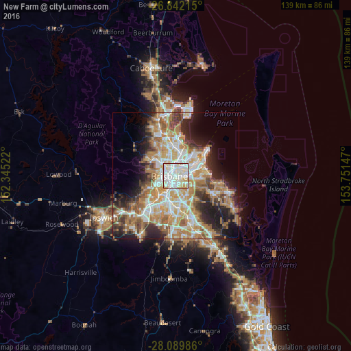
Analysis of New Farm night lights 2016
Square area 10x10 km:
 37.3%
37.3%90-99
41.07%80-89
15.87%70-79
5.75%60-69
0%50-59
0%40-49
0%30-39
0%20-29
0%10-19
0%0-9
0%Square area 50x50 km:
8.86%90-99
9.65%80-89
5.71%70-79
6.41%60-69
12%50-59
4.24%40-49
4.54%30-39
4.76%20-29
7.38%10-19
9.68%0-9
26.77%Clear (daylight) street map image can be seen on geolist.org.
Map coordinates:
26° 50' 31.7" South, 152° 20' 42.8" East
27° 28' 4" South, 153° 2' 54" East
28° 5' 23.5" South, 153° 45' 5.3" East
Some cities around New Farm sort by population:
• Brisbane
2 km =1.2 mi,  269°
269°
• Kangaroo Point
1.5 km =0.9 mi,  228°
228°
• Fortitude Valley
2 km =1.2 mi,  306°
306°
• Bulimba
2.2 km =1.4 mi,  24°
24°
• Woolloongabba
2.6 km =1.6 mi,  206°
206°
• Norman Park
1.9 km =1.2 mi,  132°
132°
• East Brisbane
1.5 km =0.9 mi,  196°
196°
• Teneriffe
1.3 km =0.8 mi,  354°
354°
2207249 (p: 12,256)
Sources (retrieved 2019-11-25):
» Earth at Night: Flat Maps 2012, 2016