Hamilton night lights from space
Night Light of Hamilton (Queensland) from space (Australia) Src. Average luminocity for 10x10km area is 95.875% and for 50x50km: 43.6125%.
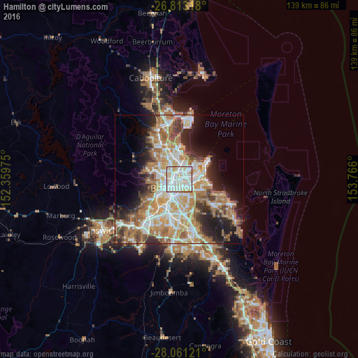
Analysis of Hamilton night lights 2016
Square area 10x10 km:
 40.34%
90-99
41.48%80-89
14.58%70-79
3.6%60-69
0%50-59
0%40-49
0%30-39
0%20-29
0%10-19
0%0-9
0%Square area 50x50 km:
8.73%90-99
9.46%80-89
5.65%70-79
6.15%60-69
11.28%50-59
4.05%40-49
4.39%30-39
4.26%20-29
6.63%10-19
9.49%0-9
29.93%Clear (daylight) street map image can be seen on geolist.org.
Map coordinates:
26° 48' 47.4" South, 152° 21' 35.1" East
27° 26' 20.3" South, 153° 3' 46.3" East
28° 3' 40.4" South, 153° 45' 57.6" East
Some cities around Hamilton sort by population:
• New Farm
3.5 km =2.2 mi,  204°
204°
• Clayfield
2.3 km =1.4 mi,  348°
348°
• Morningside
2.8 km =1.7 mi,  154°
154°
• Fortitude Valley
3.7 km =2.3 mi,  236°
236°
• Windsor
3.4 km =2.1 mi,  275°
275°
• Bulimba
1.3 km =0.8 mi, 202°
• Ascot
1 km =0.6 mi,  329°
329°
• Teneriffe
2.4 km =1.5 mi,  219°
219°
2207245 (p: 7,144)
Sources (retrieved 2019-11-25):
» Earth at Night: Flat Maps 2012, 2016