Spring Hill night lights from space
Night Light of Spring Hill (Queensland) from space (Australia) Src. Average luminocity for 10x10km area is 95.3671% and for 50x50km: 45.1052%.
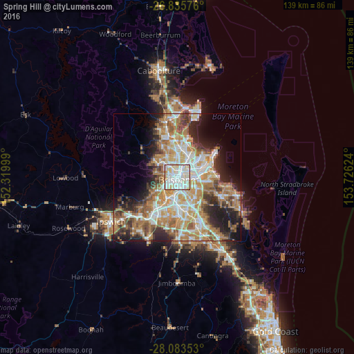
Analysis of Spring Hill night lights 2016
Square area 10x10 km:
 35.71%
90-99
43.65%80-89
17.06%70-79
3.17%60-69
0.4%50-59
0%40-49
0%30-39
0%20-29
0%10-19
0%0-9
0%Square area 50x50 km:
8.88%90-99
9.62%80-89
5.73%70-79
6.37%60-69
12%50-59
4.22%40-49
4.75%30-39
4.63%20-29
7.43%10-19
9.1%0-9
27.28%Clear (daylight) street map image can be seen on geolist.org.
Map coordinates:
26° 50' 8.7" South, 152° 19' 12" East
27° 27' 41.1" South, 153° 1' 23.2" East
28° 5' 0.7" South, 153° 43' 34.5" East
Some cities around Spring Hill sort by population:
• Brisbane
0.9 km =0.6 mi,  145°
145°
• West End
2.4 km =1.5 mi,  213°
213°
• South Brisbane
2.1 km =1.3 mi,  187°
187°
• Kangaroo Point
2.2 km =1.4 mi,  141°
141°
• Kelvin Grove
1.8 km =1.1 mi,  326°
326°
• Fortitude Valley
1 km =0.6 mi,  60°
60°
• Red Hill
2.3 km =1.4 mi,  295°
295°
• Teneriffe
2.4 km =1.5 mi,  75°
75°
2148627 (p: 7,213)
Sources (retrieved 2019-11-25):
» Earth at Night: Flat Maps 2012, 2016