East Brisbane night lights from space
Night Light of East Brisbane (Queensland) from space (Australia) Src. Average luminocity for 10x10km area is 93.8929% and for 50x50km: 45.6338%.
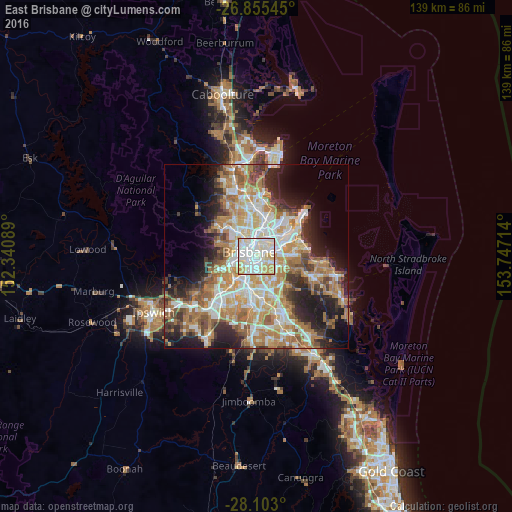
Analysis of East Brisbane night lights 2016
Square area 10x10 km:
 35.12%
90-99
38.89%80-89
15.28%70-79
10.71%60-69
0%50-59
0%40-49
0%30-39
0%20-29
0%10-19
0%0-9
0%Square area 50x50 km:
8.85%90-99
9.61%80-89
5.67%70-79
6.44%60-69
12.44%50-59
4.33%40-49
4.66%30-39
4.77%20-29
7.52%10-19
10.33%0-9
25.39%Clear (daylight) street map image can be seen on geolist.org.
Map coordinates:
26° 51' 19.6" South, 152° 20' 27.2" East
27° 28' 51.6" South, 153° 2' 38.4" East
28° 6' 10.8" South, 153° 44' 49.7" East
Some cities around East Brisbane sort by population:
• Brisbane
2.1 km =1.3 mi,  312°
312°
• Coorparoo
2 km =1.2 mi,  134°
134°
• New Farm
1.5 km =0.9 mi,  16°
16°
• South Brisbane
2.3 km =1.4 mi,  271°
271°
• Kangaroo Point
0.9 km =0.6 mi,  302°
302°
• Woolloongabba
1.1 km =0.7 mi,  221°
221°
• Norman Park
1.8 km =1.1 mi,  83°
83°
• Highgate Hill
2.6 km =1.6 mi,  250°
250°
2207258 (p: 5,735)
Sources (retrieved 2019-11-25):
» Earth at Night: Flat Maps 2012, 2016