Stanmore night lights from space
Night Light of Stanmore (New South Wales) from space (Australia) Src. Average luminocity for 10x10km area is 95.299% and for 50x50km: 45.7979%.
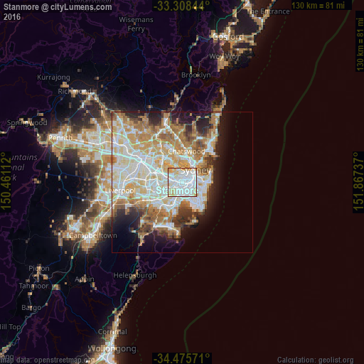
Analysis of Stanmore night lights 2016
Square area 10x10 km:
 52.62%
90-99
28.15%80-89
11.19%70-79
7.69%60-69
0.35%50-59
0%40-49
0%30-39
0%20-29
0%10-19
0%0-9
0%Square area 50x50 km:
11.18%90-99
12.12%80-89
6.12%70-79
7.07%60-69
8.05%50-59
4.05%40-49
2.59%30-39
3.38%20-29
5.01%10-19
7.71%0-9
32.74%Clear (daylight) street map image can be seen on geolist.org.
Map coordinates:
33° 18' 30.4" South, 150° 27' 40" East
33° 53' 38.7" South, 151° 9' 51.3" East
34° 28' 32.6" South, 151° 52' 2.5" East
Some cities around Stanmore sort by population:
• Marrickville
1.7 km =1.1 mi,  208°
208°
• Newtown
1.3 km =0.8 mi,  111°
111°
• Leichhardt
1.4 km =0.9 mi,  328°
328°
• Camperdown
1.2 km =0.7 mi,  66°
66°
• Annandale
1.2 km =0.7 mi,  10°
10°
• Petersham
0.9 km =0.6 mi,  266°
266°
• Erskineville
2.2 km =1.4 mi,  115°
115°
• Lilyfield
2.1 km =1.3 mi,  2°
2°
2148513 (p: 7,879)
Sources (retrieved 2019-11-25):
» Earth at Night: Flat Maps 2012, 2016