Erskineville night lights from space
Night Light of Erskineville (New South Wales) from space (Australia) Src. Average luminocity for 10x10km area is 96.9773% and for 50x50km: 42.9441%.
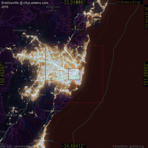
Analysis of Erskineville night lights 2016
Square area 10x10 km:
 57.52%
90-99
31.99%80-89
6.64%70-79
2.8%60-69
0.7%50-59
0%40-49
0.35%30-39
0%20-29
0%10-19
0%0-9
0%Square area 50x50 km:
10.58%90-99
11.32%80-89
5.56%70-79
6.75%60-69
7.65%50-59
3.69%40-49
2.49%30-39
3.24%20-29
4.74%10-19
6.77%0-9
37.21%Clear (daylight) street map image can be seen on geolist.org.
Map coordinates:
33° 19' 1.1" South, 150° 28' 57.6" East
33° 54' 9.1" South, 151° 11' 8.8" East
34° 29' 2.8" South, 151° 53' 20.1" East
Some cities around Erskineville sort by population:
• Newtown
0.9 km =0.6 mi,  301°
301°
• Redfern
2 km =1.2 mi,  57°
57°
• Glebe
2.6 km =1.6 mi,  356°
356°
• Camperdown
1.7 km =1.1 mi,  328°
328°
• Zetland
2.2 km =1.4 mi,  104°
104°
• Chippendale
2.1 km =1.3 mi,  31°
31°
• Alexandria
1.3 km =0.8 mi,  76°
76°
• Stanmore
2.2 km =1.4 mi, 295°
8348548 (p: 7,856)
Sources (retrieved 2019-11-25):
» Earth at Night: Flat Maps 2012, 2016