Leichhardt night lights from space
Night Light of Leichhardt (New South Wales) from space (Australia) Src. Average luminocity for 10x10km area is 93.6538% and for 50x50km: 47.2644%.
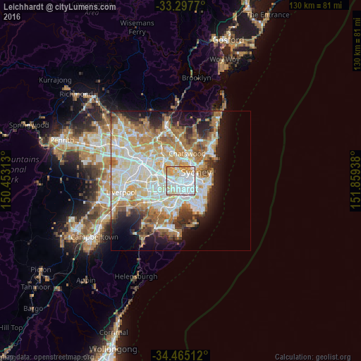
Analysis of Leichhardt night lights 2016
Square area 10x10 km:
 47.03%
90-99
27.1%80-89
12.06%70-79
12.41%60-69
1.4%50-59
0%40-49
0%30-39
0%20-29
0%10-19
0%0-9
0%Square area 50x50 km:
11.4%90-99
12.41%80-89
6.44%70-79
7.22%60-69
8.24%50-59
4.2%40-49
2.66%30-39
3.62%20-29
5.31%10-19
8.87%0-9
29.62%Clear (daylight) street map image can be seen on geolist.org.
Map coordinates:
33° 17' 51.7" South, 150° 27' 11.3" East
33° 53' 0.3" South, 151° 9' 22.5" East
34° 27' 54.4" South, 151° 51' 33.8" East
Some cities around Leichhardt sort by population:
• Glebe
2.6 km =1.6 mi,  78°
78°
• Camperdown
2 km =1.2 mi,  110°
110°
• Annandale
1 km =0.6 mi,  89°
89°
• Petersham
1.2 km =0.7 mi,  185°
185°
• Stanmore
1.4 km =0.9 mi,  148°
148°
• Lilyfield
1.3 km =0.8 mi,  41°
41°
• Summer Hill
1.9 km =1.2 mi,  241°
241°
• Haberfield
1.1 km =0.7 mi,  272°
272°
2160386 (p: 14,373)
Sources (retrieved 2019-11-25):
» Earth at Night: Flat Maps 2012, 2016