Rozelle night lights from space
Night Light of Rozelle (New South Wales) from space (Australia) Src. Average luminocity for 10x10km area is 91.8129% and for 50x50km: 46.0473%.
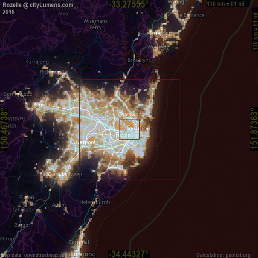
Analysis of Rozelle night lights 2016
Square area 10x10 km:
 42.31%
90-99
24.65%80-89
11.36%70-79
18.88%60-69
2.8%50-59
0%40-49
0%30-39
0%20-29
0%10-19
0%0-9
0%Square area 50x50 km:
11.05%90-99
11.99%80-89
6.05%70-79
6.96%60-69
8.28%50-59
4.08%40-49
2.59%30-39
3.74%20-29
5.35%10-19
9.31%0-9
30.6%Clear (daylight) street map image can be seen on geolist.org.
Map coordinates:
33° 16' 32" South, 150° 28' 2.6" East
33° 51' 41.1" South, 151° 10' 13.8" East
34° 26' 35.8" South, 151° 52' 25.1" East
Some cities around Rozelle sort by population:
• Leichhardt
2.8 km =1.7 mi,  208°
208°
• Pyrmont
2.4 km =1.5 mi,  113°
113°
• Drummoyne
1.8 km =1.1 mi,  304°
304°
• Glebe
2.3 km =1.4 mi,  146°
146°
• Balmain
1.4 km =0.9 mi,  58°
58°
• Annandale
2.5 km =1.6 mi,  188°
188°
• Lilyfield
1.6 km =1 mi,  197°
197°
• Greenwich
2.7 km =1.7 mi,  25°
25°
8015348 (p: 8,542)
Sources (retrieved 2019-11-25):
» Earth at Night: Flat Maps 2012, 2016