Balmain night lights from space
Night Light of Balmain (New South Wales) from space (Australia) Src. Average luminocity for 10x10km area is 90.3794% and for 50x50km: 44.542%.
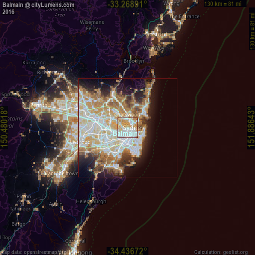
Analysis of Balmain night lights 2016
Square area 10x10 km:
 38.81%
90-99
23.95%80-89
11.71%70-79
18.18%60-69
6.82%50-59
0.52%40-49
0%30-39
0%20-29
0%10-19
0%0-9
0%Square area 50x50 km:
10.77%90-99
11.57%80-89
5.61%70-79
6.79%60-69
8.1%50-59
3.92%40-49
2.52%30-39
3.72%20-29
5.22%10-19
8.91%0-9
32.87%Clear (daylight) street map image can be seen on geolist.org.
Map coordinates:
33° 16' 8.1" South, 150° 28' 48.6" East
33° 51' 17.3" South, 151° 10' 59.9" East
34° 26' 12.2" South, 151° 53' 11.1" East
Some cities around Balmain sort by population:
• Sydney
2.6 km =1.6 mi,  123°
123°
• Sydney Central Business District
2.5 km =1.6 mi, 116°
• Pyrmont
1.9 km =1.2 mi,  149°
149°
• Drummoyne
2.6 km =1.6 mi,  275°
275°
• Glebe
2.7 km =1.7 mi,  178°
178°
• Rozelle
1.4 km =0.9 mi,  238°
238°
• Wollstonecraft
2.5 km =1.6 mi,  13°
13°
• Greenwich
1.7 km =1.1 mi,  359°
359°
2177052 (p: 10,305)
Sources (retrieved 2019-11-25):
» Earth at Night: Flat Maps 2012, 2016