Ringwood night lights from space
Night Light of Ringwood (Victoria) from space (Australia) Src. Average luminocity for 10x10km area is 69.8044% and for 50x50km: 40.8389%.
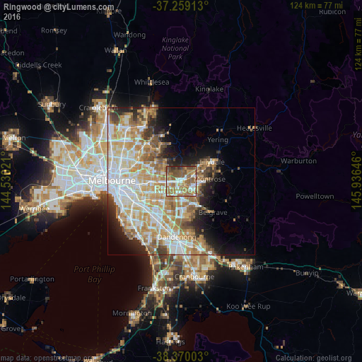
Analysis of Ringwood night lights 2016
Square area 10x10 km:
 12.24%
90-99
11.56%80-89
6.12%70-79
11.56%60-69
25.68%50-59
18.37%40-49
11.56%30-39
1.19%20-29
1.7%10-19
0%0-9
0%Square area 50x50 km:
9.41%90-99
9.36%80-89
4.84%70-79
7.92%60-69
7.02%50-59
5.21%40-49
3.37%30-39
2.86%20-29
4.66%10-19
6.71%0-9
38.64%Clear (daylight) street map image can be seen on geolist.org.
Map coordinates:
37° 15' 32.9" South, 144° 31' 48.8" East
37° 49' 0" South, 145° 13' 60" East
38° 22' 12.1" South, 145° 56' 11.3" East
Some cities around Ringwood sort by population:
• Croydon
4.8 km =3 mi,  67°
67°
• Mitcham
2.9 km =1.8 mi,  270°
270°
• Wantirna
4 km =2.5 mi,  201°
201°
• Nunawading
5.3 km =3.3 mi, 265°
• Bayswater
4.7 km =2.9 mi,  141°
141°
• Forest Hill
4.8 km =3 mi,  247°
247°
• Vermont
4.1 km =2.5 mi,  237°
237°
• Heathmont
2.4 km =1.5 mi, 141°
2151576 (p: 17,242)
Sources (retrieved 2019-11-25):
» Earth at Night: Flat Maps 2012, 2016