Mitcham night lights from space
Night Light of Mitcham (Victoria) from space (Australia) Src. Average luminocity for 10x10km area is 71.0255% and for 50x50km: 44.1056%.
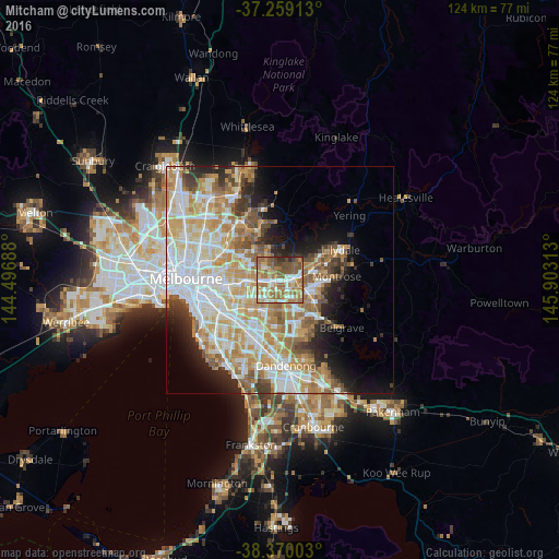
Analysis of Mitcham night lights 2016
Square area 10x10 km:
 11.05%
90-99
12.93%80-89
7.82%70-79
13.61%60-69
26.87%50-59
14.97%40-49
9.86%30-39
1.19%20-29
1.7%10-19
0%0-9
0%Square area 50x50 km:
10.83%90-99
10.1%80-89
5.4%70-79
8.35%60-69
7.21%50-59
5.3%40-49
3.45%30-39
2.99%20-29
4.87%10-19
6.95%0-9
34.57%Clear (daylight) street map image can be seen on geolist.org.
Map coordinates:
37° 15' 32.9" South, 144° 29' 48.8" East
37° 49' 0" South, 145° 12' 0" East
38° 22' 12.1" South, 145° 54' 11.3" East
Some cities around Mitcham sort by population:
• Ringwood
2.9 km =1.8 mi,  90°
90°
• Wantirna
4 km =2.5 mi,  158°
158°
• Blackburn
4.1 km =2.5 mi,  266°
266°
• Donvale
3.8 km =2.4 mi,  324°
324°
• Nunawading
2.4 km =1.5 mi,  259°
259°
• Forest Hill
2.4 km =1.5 mi,  218°
218°
• Vermont
2.2 km =1.4 mi,  193°
193°
• Ringwood North
3.5 km =2.2 mi,  57°
57°
2157410 (p: 15,861)
Sources (retrieved 2019-11-25):
» Earth at Night: Flat Maps 2012, 2016