Saint Ives night lights from space
Night Light of Saint Ives (New South Wales) from space (Australia) Src. Average luminocity for 10x10km area is 54.9304% and for 50x50km: 39.256%.
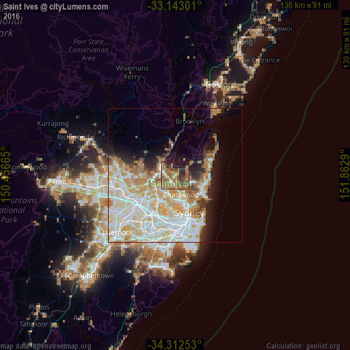
Analysis of Saint Ives night lights 2016
Square area 10x10 km:
 3.11%
3.11%90-99
3.85%80-89
4.58%70-79
8.42%60-69
32.42%50-59
13.74%40-49
7.33%30-39
6.96%20-29
10.99%10-19
8.61%0-9
0%Square area 50x50 km:
9.99%90-99
10.82%80-89
5.78%70-79
6.31%60-69
6.34%50-59
2.49%40-49
1.59%30-39
2.19%20-29
3.38%10-19
6.26%0-9
44.83%Clear (daylight) street map image can be seen on geolist.org.
Map coordinates:
33° 8' 34.8" South, 150° 27' 23.9" East
33° 43' 47.1" South, 151° 9' 35.2" East
34° 18' 45.1" South, 151° 51' 46.4" East
Some cities around Saint Ives sort by population:
• Wahroonga
4.3 km =2.7 mi,  287°
287°
• Turramurra
2.9 km =1.8 mi,  261°
261°
• Pymble
2.3 km =1.4 mi,  226°
226°
• Killara
4 km =2.5 mi,  176°
176°
• Belrose
4.8 km =3 mi,  103°
103°
• Gordon
3 km =1.9 mi,  195°
195°
• Waitara
5.6 km =3.5 mi, 291°
• West Pymble
4.8 km =3 mi,  210°
210°
2150669 (p: 17,036)
Sources (retrieved 2019-11-25):
» Earth at Night: Flat Maps 2012, 2016