Normanhurst night lights from space
Night Light of Normanhurst (New South Wales) from space (Australia) Src. Average luminocity for 10x10km area is 62.359% and for 50x50km: 45.1394%.
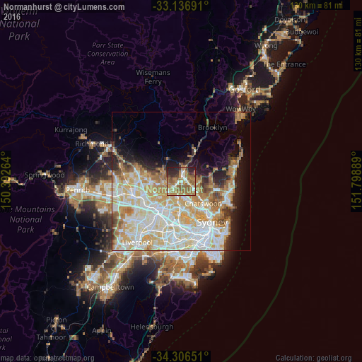
Analysis of Normanhurst night lights 2016
Square area 10x10 km:
 6.78%
6.78%90-99
10.81%80-89
3.11%70-79
11.72%60-69
29.3%50-59
13.37%40-49
4.95%30-39
5.49%20-29
13.55%10-19
0.92%0-9
0%Square area 50x50 km:
11.04%90-99
12.27%80-89
6.59%70-79
7.63%60-69
7.44%50-59
3.15%40-49
2.19%30-39
2.84%20-29
3.91%10-19
6.85%0-9
36.09%Clear (daylight) street map image can be seen on geolist.org.
Map coordinates:
33° 8' 12.9" South, 150° 23' 33.5" East
33° 43' 25.3" South, 151° 5' 44.7" East
34° 18' 23.4" South, 151° 47' 56" East
Some cities around Normanhurst sort by population:
• Hornsby
2.4 km =1.5 mi,  7°
7°
• Cherrybrook
4.6 km =2.9 mi,  272°
272°
• Wahroonga
1.9 km =1.2 mi,  71°
71°
• Turramurra
3.2 km =2 mi,  109°
109°
• Beecroft
4.1 km =2.5 mi,  224°
224°
• Thornleigh
1.8 km =1.1 mi,  238°
238°
• Pennant Hills
2.7 km =1.7 mi,  234°
234°
• Waitara
1.6 km =1 mi,  26°
26°
2155092 (p: 5,211)
Sources (retrieved 2019-11-25):
» Earth at Night: Flat Maps 2012, 2016