Woolloongabba night lights from space
Night Light of Woolloongabba (Queensland) from space (Australia) Src. Average luminocity for 10x10km area is 93.254% and for 50x50km: 45.8514%.
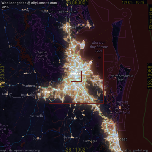
Analysis of Woolloongabba night lights 2016
Square area 10x10 km:
 32.94%
90-99
37.3%80-89
17.46%70-79
11.71%60-69
0.6%50-59
0%40-49
0%30-39
0%20-29
0%10-19
0%0-9
0%Square area 50x50 km:
8.88%90-99
9.58%80-89
5.64%70-79
6.47%60-69
12.5%50-59
4.34%40-49
4.83%30-39
4.86%20-29
7.67%10-19
10.53%0-9
24.71%Clear (daylight) street map image can be seen on geolist.org.
Map coordinates:
26° 51' 47" South, 152° 20' 0.3" East
27° 29' 18.8" South, 153° 2' 11.6" East
28° 6' 37.9" South, 153° 44' 22.8" East
Some cities around Woolloongabba sort by population:
• Brisbane
2.4 km =1.5 mi,  339°
339°
• Coorparoo
2.2 km =1.4 mi,  103°
103°
• New Farm
2.6 km =1.6 mi,  26°
26°
• Greenslopes
2.5 km =1.6 mi,  149°
149°
• South Brisbane
1.8 km =1.1 mi,  299°
299°
• Kangaroo Point
1.3 km =0.8 mi,  0°
0°
• Highgate Hill
1.8 km =1.1 mi,  267°
267°
• East Brisbane
1.1 km =0.7 mi,  41°
41°
6943568 (p: 6,321)
Sources (retrieved 2019-11-25):
» Earth at Night: Flat Maps 2012, 2016