Naremburn night lights from space
Night Light of Naremburn (New South Wales) from space (Australia) Src. Average luminocity for 10x10km area is 76.7028% and for 50x50km: 41.4291%.
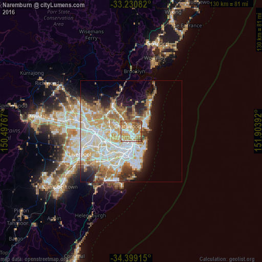
Analysis of Naremburn night lights 2016
Square area 10x10 km:
 12.59%
90-99
17.31%80-89
8.22%70-79
22.9%60-69
26.92%50-59
6.64%40-49
5.07%30-39
0.35%20-29
0%10-19
0%0-9
0%Square area 50x50 km:
9.96%90-99
10.73%80-89
5.33%70-79
6.62%60-69
7.67%50-59
3.45%40-49
2.28%30-39
3.37%20-29
4.62%10-19
7.34%0-9
38.63%Clear (daylight) street map image can be seen on geolist.org.
Map coordinates:
33° 13' 51" South, 150° 29' 51.6" East
33° 49' 1.1" South, 151° 12' 2.8" East
34° 23' 56.9" South, 151° 54' 14.1" East
Some cities around Naremburn sort by population:
• Chatswood
2.5 km =1.6 mi,  319°
319°
• Artarmon
1.6 km =1 mi,  271°
271°
• Wollstonecraft
2 km =1.2 mi,  209°
209°
• North Sydney
2.5 km =1.6 mi,  166°
166°
• Cammeray
1.5 km =0.9 mi,  108°
108°
• Willoughby
1.3 km =0.8 mi,  354°
354°
• St Leonards
0.8 km =0.5 mi,  197°
197°
• Northbridge
1.6 km =1 mi,  74°
74°
8347890 (p: 5,772)
Sources (retrieved 2019-11-25):
» Earth at Night: Flat Maps 2012, 2016